New Zealanders across several southern and central regions are being urged to prepare for a wet and windy weekend as forecasters warn of heavy rain and severe northwest gales moving across the country.
Weather authorities have issued multiple watches and warnings as a powerful front approaches the South Island before gradually moving northward through the weekend. While winter weather is nothing unusual for New Zealand, the latest forecasts suggest some areas could experience significant rainfall, strong winds, and difficult travel conditions.
For many residents, particularly those in flood-prone regions or exposed coastal communities, the coming days may require extra caution and preparation.
What Is Happening?
Meteorologists say a strong northwest flow is expected to push a weather front onto the lower South Island before it tracks north through southern and central New Zealand.
The system is forecast to bring periods of heavy rain, particularly to parts of the West Coast and other exposed regions, while severe northwest winds could affect several districts as the front advances.
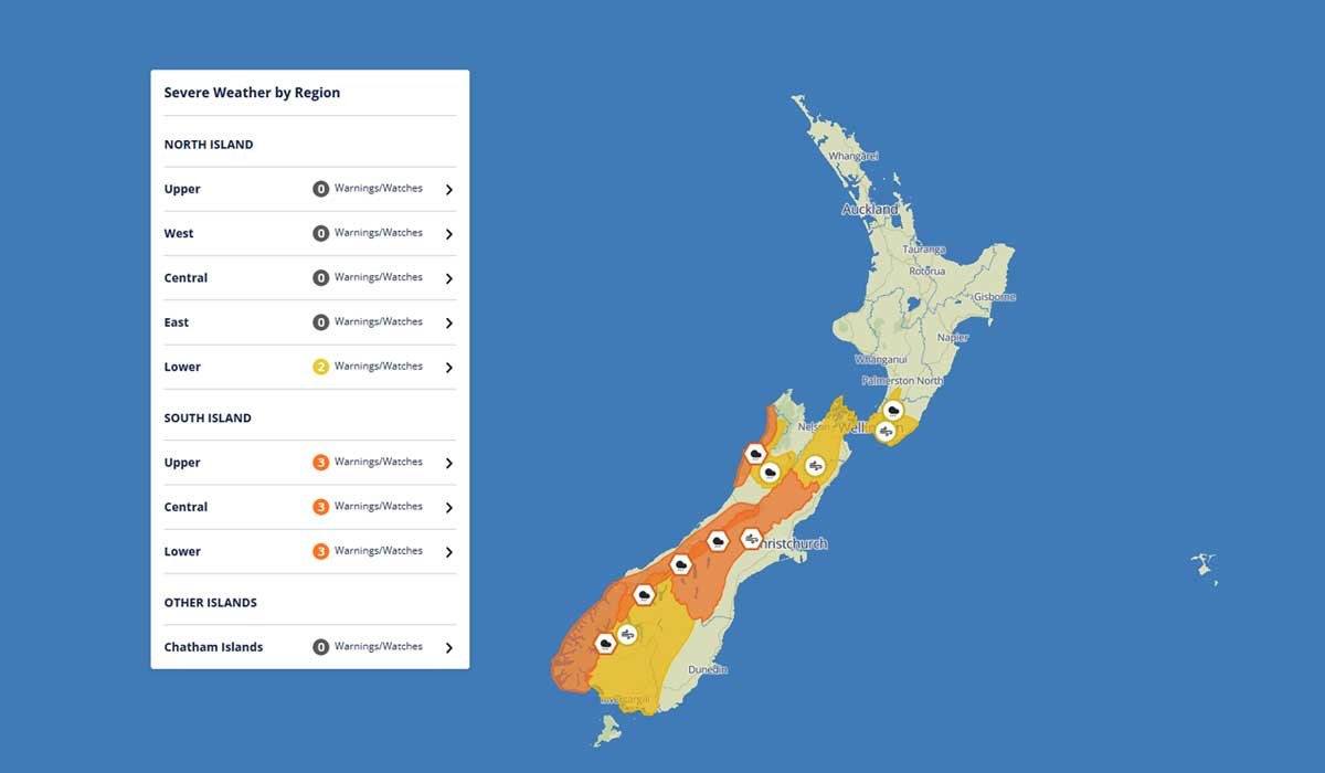
Weather watches and warnings have already been issued, highlighting the potential for disruptive conditions over the weekend.
According to forecasts, some locations could receive substantial rainfall within a relatively short period, increasing the risk of surface flooding and rapidly rising waterways.
Areas Under Heavy Rain Warning
One of the most significant warnings currently in place covers the coastal ranges of Buller and Grey districts on the West Coast.
Forecasters expect between 80mm and 130mm of rainfall in these areas over a period stretching from Saturday morning into Sunday.
Peak rainfall rates could reach between 15mm and 25mm per hour during the most intense periods.
While weather experts say there is currently only a minimal chance that warnings will need to be upgraded further, residents are being advised to closely monitor forecasts as conditions develop.
Heavy rain of this intensity can quickly overwhelm drainage systems and lead to localised flooding, especially in areas that have already experienced wet conditions in recent weeks.
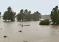
Flooding and Travel Concerns
One of the primary concerns associated with the incoming weather system is the potential impact on transport networks.
Heavy rainfall may cause streams and rivers to rise rapidly, increasing the risk of flooding in low-lying areas. Water pooling on roads can also create hazardous driving conditions, particularly during periods of reduced visibility.
Motorists travelling through affected regions this weekend are being encouraged to allow extra travel time and remain alert to changing weather conditions.
Slips and debris on roads remain another possibility, particularly in hilly and mountainous areas where prolonged rainfall can destabilise slopes.
For rural communities, heavy rain can also affect farm operations, stock management, and access routes.


