As New Zealand gears up for New Year’s Eve 2025 celebrations, weather authorities have issued a severe thunderstorm watch for large parts of the North Island, with conditions expected to be unsettled for many communities.
What’s Happening?
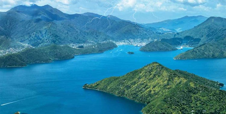
Meteorologists say an active low-pressure system moving near the country is pulling moist, unstable air over the North Island. This will bring showers and thunderstorms across a broad stretch of the region from mid-afternoon into the evening.
The severe thunderstorm watch is currently in force from about 1 pm to 10 pm today for a long list of regions including Northland, Auckland, Waikato, Taranaki, Manawatū, Wellington and others.


What to Expect
- Thunderstorms likely through the “spine” of the North Island – from the far north down towards Wellington.
- Heavy downpours and possible gusty winds in storm cells.
- Lightning and thunder could interrupt outdoor New Year’s Eve plans.
While Hawke’s Bay and parts of Gisborne might escape the worst of the wet weather, many other areas will need to be alert and prepared for changeable conditions.
Beyond the North Island
Meanwhile, the upper South Island is also seeing heavy rain as the system pushes moisture into mountainous zones, potentially bringing significant rainfall through New Year’s Day.
North Island New Year’s Eve Weather: Key Points
| Feature | Forecast |
|---|---|
| Watch Type | Severe thunderstorm watch |
| Time Window | ~1 pm – 10 pm (today) |
| Areas Affected | Most of the North Island core regions |
| Weather Hazards | Thunderstorms, showers, gusty winds |
| Better Weather Spots | Eastern areas like Hawke’s Bay |
FAQs: New Year’s Eve Weather in NZ
What does a “severe thunderstorm watch” mean?
A severe thunderstorm watch means conditions are favourable for storms that could produce heavy rain, strong winds, lightning, or hail. It doesn’t guarantee a storm, but people should stay alert and check the latest updates.
Will fireworks displays go ahead?
Some events have already been cancelled or postponed in response to forecast winds and rain. Always check local council or event updates before heading out.
Which areas might miss the storms?
Eastern regions such as Hawke’s Bay and Gisborne may see more settled, drier conditions compared with the rest of the North Island.
How should I prepare?
Bring waterproof clothing, allow extra travel time, and have a plan if outdoor celebrations get wet. Thunderstorms can also bring flash flooding in low-lying areas.
Disclaimer
This article is an original weather overview based on weather forecasts and local observations as of 30 December 2025. Weather conditions can change rapidly; always consult official forecasts and local authorities for the most up-to-date and location-specific information.


